Craving crowd-free serenity? Longing for pristine beaches? Fascinated by wildife, nature, and history? From southern California, to the Pacific Northwest, to the southeastern Atlantic shore, these gorgeous archipelagos just off the US coast are exactly what you need.
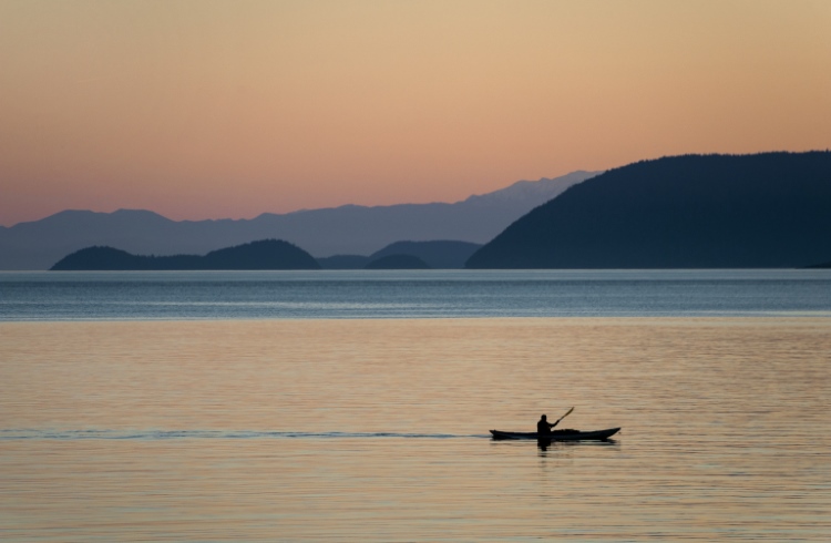 Photo © Getty Images / Edmund Lowe
- The Channel Islands of California
- Washington’s San Juan Islands
- The Sea Islands of South Carolina and Georgia
The Channel Islands of California
It was a fascination with island ecology that led me to the Channel Islands of California. I had a pilgrimage to the Galápagos planned, but my wallet had other ideas, and the more I read about evolution, the more satisfied I was that if I wanted to see Mother Nature at her inventive best, I didn’t need to join legions of travelers on a quest for a giant tortoise selfie in Ecuador.
Islands are laboratories for biodiversity, places where natural selection has produced a remarkable array of creatures unique to their locales. Darwin may have had his “eureka” moment on the Galápagos, but he could have had it in Borneo, South Georgia, Coiba or…
The Channel Islands.
This archipelago of just eight small, mostly uninhabited islands, between 12-64mi (19-103km) from the Californian mainland, is home to more than 2,000 animal and plant species, 145 of which are found nowhere else on Earth.
Five of those islands – Anacapa, Santa Cruz, San Miguel, Santa Rosa, and Santa Barbara – comprise the Channel Islands National Park, and their surrounding waters are a National Marine Sanctuary. Of the three remaining islands, only Santa Catalina, a tourist destination first developed by the chewing gum magnate William Wrigley Jr. in the 1920s, is open to the public and not owned by the US Navy.
My first glimpse of the archipelago was on an Island Packers whale watching tour out of Ventura, California. That day in late March, the waters were churning with activity – fin, humpback and California gray whales, large pods of dolphins – but what really grabbed me was the sight of Anacapa rising up out of the fog like a gothic galleon. I determined to learn more.
Within a month I had arranged my trip. A contact, a research scientist with the United States Geological Survey, found a room for me in Avalon, a resort town of about 3,700 people on Santa Catalina.
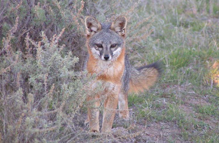
He and his colleagues treated me as a fellow researcher. With the use of a private boat (there are others ways to explore - see below), I spent 10 days exploring each of the park’s islands, kayaking into some of the world’s deepest sea caves, watching elephant seals nurse their giant pups, and hiking trails through intensely beautiful yet slightly alien landscapes. I lay in wait like a paparazzo for the Channel Island fox (not in the least bit flustered by my presence), Island scrub jay, deer mouse, fence lizard, spotted skunk, and slender salamander, each endemic, as a species or subspecies, to the Channel Islands.
The human story told here is every bit as affecting, from the earliest dated remains in the Americas being found on Santa Rosa (proof that Paleoindians settled California 13,000 years ago and watercraft were in use by then) to the advanced culture of the indigenous Chumash and Tongva peoples, who were later effectively enslaved by European colonists. As the Catalina Museum in Avalon spells out, the “civilized” colonists brought ranching, gold mining, and the trade in sea otter fur, the ill effects of which the Channel Islands have spent the past 100 years trying to recover from.
How to get there
If you don’t have friends in the USGS, it’s still very possible to explore the islands. The Channel Islands National Park is accessible by boat and plane (to San Miguel and Santa Rosa from Camarillo Airport). Island Packers is the sole concessionaire for boat transportation, leaving from Ventura and Oxnard harbors. Journeys take between an hour and three and a half hours, one way, and round-trip day fares range from US $68 to $115. Kayaks can be rented, and you can camp with Island Packers on Anacapa, Santa Cruz, Santa Rosa, and San Miguel. Visit flycia.com and islandpackers.com for details and to book.
Two companies offer a high-speed ferry service to Santa Catalina from Long Beach, San Pedro, Dana Point and Newport Beach. – Joe Furey
Washington’s San Juan Islands
An archipelago located off the west coast of Washington state, the San Juan islands offer some of the most quintessential Pacific Northwest landscapes – thickets of evergreen trees spilling into deep, lapis-blue waters and expansive coastline. Just a short drive and a ferry ride from Seattle, these islands are accessible, but feel a world away from mainland Washington state, offering at once adventure and serenity.
Having lived on and off in Seattle for the better part of my life, the San Juan Islands are one of my favorite weekend getaways from the city, particularly during the fleeting and glorious summer months. I have frequented the San Juan Islands several times over the years, including my best friend’s wedding, camping trips with friends, and weekends spent exploring local pottery shops and remote beaches with my mom. Of all the islands, spectacular Orcas Island is the one that draws me back time and again.
Getting to the San Juan Islands – whether you choose to go to San Juan, Orcas, Lopez, or one of the smaller islands – is always part of the adventure. As soon as the ferry departs from Anacortes Ferry Terminal, about a 1.5-hour drive north from Seattle, I head to the windy top deck and watch as the mainland disappears into the horizon. The one-hour trip passes peacefully as the waves lap against the ferry and the rolling green hills and the harbor of Orcas Island draws closer.
Exploring Orcas Island
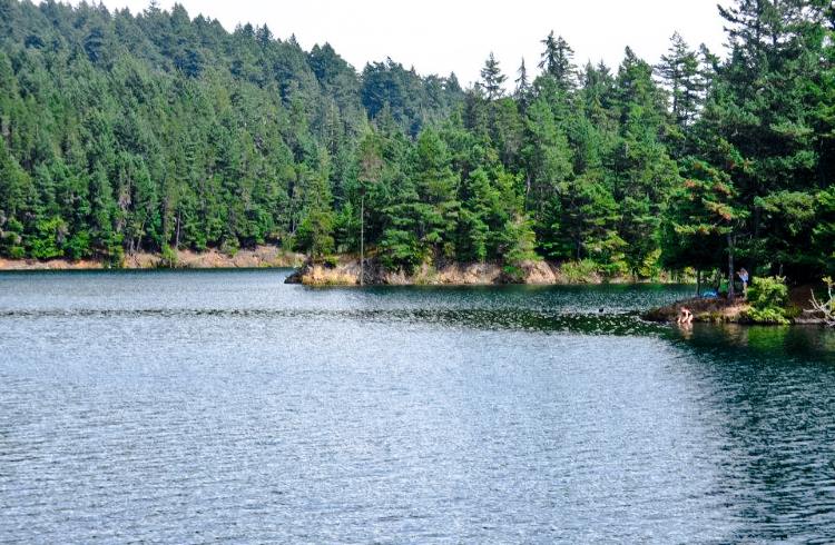
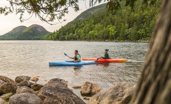
Orcas Island is filled with treasures: the majestic coastline and secluded bays, and the rugged interior filled with farms, artisan shops, forests, and lakes. I’ve spent days kayaking the glassy waters with stops on uninhabited islands, and others on whale watching adventures where it’s possible to spot orcas, humpbacks, sea lions, and other Pacific Northwest marine life. Secluded Doe Bay, on the eastern coast, is a phenomenal place to relax and catch the tunes of local musicians. After a day of exploring the outdoors, I often take a stroll along the colorful streets of Eastsound, the small downtown area of Orcas Island, filled with cafes, local art galleries, and bookshops.
On a foggy morning on my last visit, I hiked to the top of Mt. Constitution with friends, the highest point on the San Juans. The summit offers sweeping views over the forested island, sparkling waters, and nearby islands. After a morning of hiking, we continued the winding drive through Moran State Park deeper into the interior of the island. We relaxed on the docks of Mountain Lake beneath the warm afternoon sun and floated in the pristine water, surrounded by statuesque evergreens. In the evening, we headed back to our campsite on a cliff’s edge and watched as a supermoon rose over the water, creating a jagged, silvery reflection. Moments like these are what keep me coming back.
Trip notes
Airbnb rentals, bed and breakfasts, farm stays, and grassy campgrounds are among the accommodation options. The San Juan Islands are an extremely popular destination during the summer months and places fill up quickly. Book in advance (campgrounds included) to avoid disappointment, or consider traveling during off months, even though the weather will be less predictable. Rates also vary by season. Campgrounds can be booked for US $40-$50 per night per vehicle, while cabins and cottages from $120-$350/night. Kayak tours start at around $90 for three hours and go up from there the longer the trip, while whale watching tours range from $79-99. The islands are easily reached and can be experienced without a tour, though a car is required. If boarding the ferry with a vehicle, advance reservations are strongly recommended. – Alicia Erickson
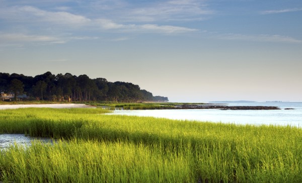
The Sea Islands of South Carolina and Georgia
I have always sought out coastal areas – deltas and estuaries, wetlands, marshes, tidal zones. They are liminal spaces, ever on the threshold of being this, that, or the other, their physical reality a matter of meteorological opinion, subject to the whims of the wind and waves.
And nowhere can this be better appreciated than in the Sea Islands, the chain of 100-plus barrier islands that break up the Atlantic coast between the mouths of the Santee River, in South Carolina, and St. Johns River, in Florida.
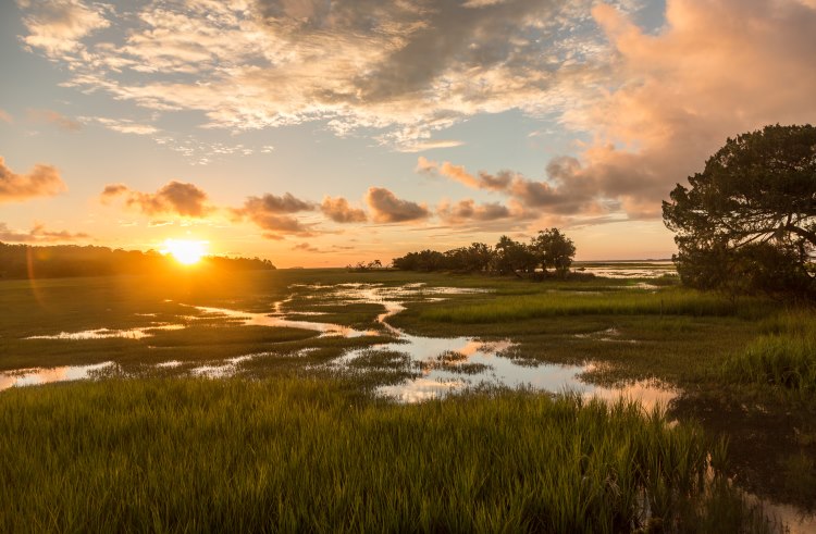
I return to the region each October, to fish, to surf, to just be. There’s nothing quite like walking down a dirt road on South Carolina’s Dafuskie Island, savoring each footfall, until the packed earth and the live oaks flanking it give way to a stretch of sand that faces the not-yet-cold Atlantic Ocean.
With dining and art scenes of international standing, Charleston, SC is wearing its 349 years well, and the city makes a good base from which to explore the islands on either side of it. I’m also happy to report that, although it was built on slave labor, and the first shots of the Civil War were fired in its harbor, the International African American Museum is slated to open on the site of a former slave market there in 2022.
South Carolina’s barrier islands: Sullivan’s, Bull’s, Folly, and Hilton Head
Sullivan’s Island, at the mouth of Charleston Harbor, should be as well-known as Ellis Island in New York. It was the point of entry for – it has been widely estimated – 400,000 enslaved Africans brought to British North America, and 50% of all African Americans are thought to have ancestors who passed through here. There is a memorial bench, provided by the writer Toni Morrison, on which I’ve seen whole families weeping.
Bull’s Island is part of the Cape Romain National Wildlife Refuge (favored by loggerhead turtles and more than 293 species of birds) and became the site of the red wolf breeding program, the intention of which was to reintroduce viable pairs into the wild. Sadly, that has not been a great success, but other suitable habitats have been identified and permissions sought for the release of future wolves.
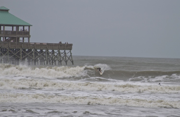
Called “the edge of America” by locals, Folly Beach, a small boho-y town, is Folly Island’s main attraction. It’s also the heart of South Carolina’s surf scene. In the fall, under the right conditions – hurricane swells and powerful nor’easters – it can inspire an amateur like me to not look a total kook. If it’s crowded, try the nearby Isle of Palms.
The site of the first “green” resort in the US, Hilton Head Island is rather swanky, but there’s an air of generosity about it. It’s where the town of Mitchelville, the first self-governing community of freed slaves, was built during the Civil War. With a language and culture rich in Central and West African influences, the Gullah, who are direct descendants of Mitchelville’s founders, steer much of the cultural life on the island.
Georgia’s barrier islands: Tybee, Ossabaw, and Cumberland
Just 20 minutes from Savannah, Georgia, Tybee Island has a faded-genteel, sun-streaked, five-miles-of-public-beach charm. Slurp a cold root beer in the shadow of its vintage lighthouse and ponder that the French and Spanish once fought a battle here over control of your drink’s chief flavoring, sassafras.
From Tybee it’s a short boat trip to the mysterious Ossabaw Island, whose 13 miles of sand are open to the public from sunrise to sunset, but since Ossabaw is a heritage preserve, visitors can’t go beyond the dunes unless they sign up for something improving, like a creative retreat, indigo workshop, or an archaeology dig. (Sign up in advance.)
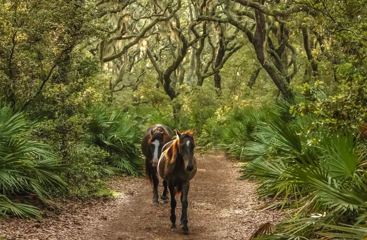
The ferry from St. Mary’s, on the Georgia mainland, to Cumberland Island might as well be a rocket, because it takes you to somewhere so gloriously other. 16 miles long and extending almost as far south as Florida, the island contains one of the largest barrier island Wilderness Areas in the country; maritime forests, marshes, uncombed beaches, and wild horses whose bloodlines can be traced back to the stables of the King of Arabia. You’ll need to make reservations, as visitor numbers are limited, and then come up with excuses for why you’re not able to leave. – Joe Furey
Related articles
Simple and flexible travel insurance
You can buy at home or while traveling, and claim online from anywhere in the world. With 150+ adventure activities covered and 24/7 emergency assistance.
Get a quote
2 Comments
Can someone explain what this sentence in the last paragraph means? "...the island contains the largest federally designated wilderness area in the contiguous US". According to the National Park Service, the island has more than 9,800 acres. But Death Valley, straddling the contiguous-US states of California & Nevada, has more than 3 million acres. In fact, there are five wilderness areas over 1 million acres - also in Montana, Idaho, and Florida (the Everglades).
Does the author mean largest in the National Seashore? Is there some other qualifier missing?
Hi Kris,
Thanks for the catch - we have amended that paragraph.