The Swiss Alps may be famous for skiing, but it’s also a glorious summertime playground. Tim Neville shares his favorite places to swim, hike, and bike.
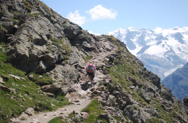 Photo © Tim Neville
If I could pick any place in the world to while away a warm, sunny day, it will almost always be Switzerland. Specifically, I’d be high on a fuzzy alpine meadow, snoozing in the lupine with legs heavy from the hike it took to get there. And then, I’d add in all the other places I’d go and all the other things I’d do on other days. With awesome water to float, huge mountains to wander, and more bike paths to ride than any country this size should rightfully have, Switzerland in the summertime is mein happy platz. Here are the highlights of my decades-long love affair.
Swimming the Aare River in Bern
For a few years in the late aughts, I moved back to Switzerland for the second time – this time with my family – to Bern, Switzerland's de facto capital in the west-central part of the country, where I quickly discovered one of the greatest urban rituals anywhere.
Summers there can get hot for Switzerland (32ºC / 90ºF) with a punishing sun that seems to gather off the buildings and the distant Alps to triple roast you alive. On real scorchers, hundreds of us working volk would make our way down the cobblestone streets to our salvation: the brawny River Aare that runs cool and green through the center of the city. It’s not famous like the Rhine or the Rhône, but the Aare belongs only to the Swiss, a 180mi (290km) tributary of the High Rhine that begins and ends entirely within the country. The slice that wraps around Bern may be its most beautiful, a horseshoe of fairy-green water cupping a UNESCO-listed warren of medieval streets and buildings with geraniums piped around the balconies. On some stretches you’ll see nothing but forest along the Aare’s banks. On others, you’re right under Parliament.
On those days, I’d ride my bike down to the river and lash it to a low-slung footbridge called the Schönausteg that crosses the Aare near the zoo. I’d trade my sweaty work clothes for swimming shorts and fall in line with the bare-footed masses. We’d pad our way upstream along a sun-warmed footpath to a broad grassy park with big trees called Eichholz. There, I’d ease into the shoulders of the current, feel my skin clinch in the cold, and let the city scroll by with scores of other bobbing heads.
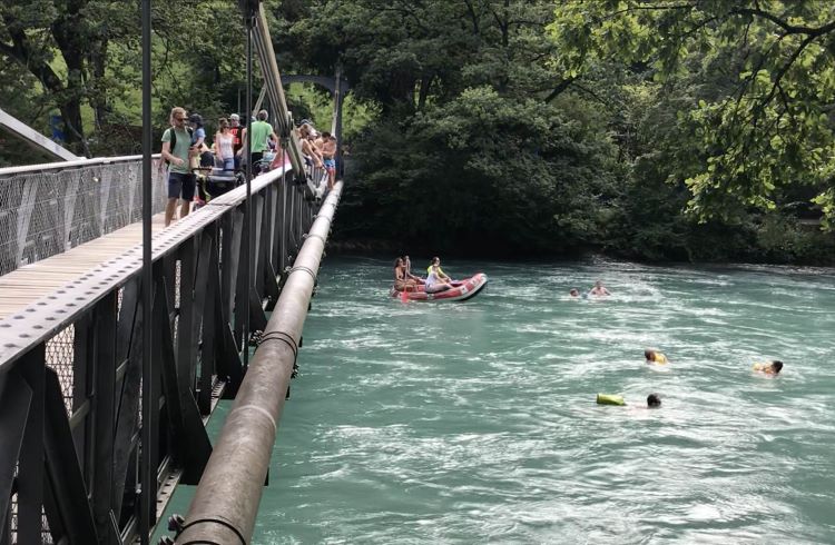
The two-kilometer float down to a public swimming pool called the Marzilibad goes by fast, but it’s tiring, since you must tread water in a very stiff current that makes strong swimming skills a must. Still, there are no rapids like on the River Inn, in far eastern Switzerland, where I once bounced in a raft through class III and IV waves pinched between rugged canyon walls. For no current at all, I’d go south to Lake Geneva, where pockets of stony beaches in places such as Lausanne and Geneva’s Bains des Pâquis twinkle in the sunlight under shimmering peaks and vineyards.
But the Aare was always my warm-weather favorite. I’d check sites like aareguru.ch for the water temperature and current (hilariously measured in glasses of beer flowing by per second). I’d float my way down to the Marzilibad, where some long steps with red handrails line the banks. I’d either grab one and get out, or, feeling lazy, I’d float a few feet farther to a concrete canal, specifically built for river swimmers, that feeds them from the Aare into the riverside pool without ever having to get out.
Then I’d walk upstream and do it again.
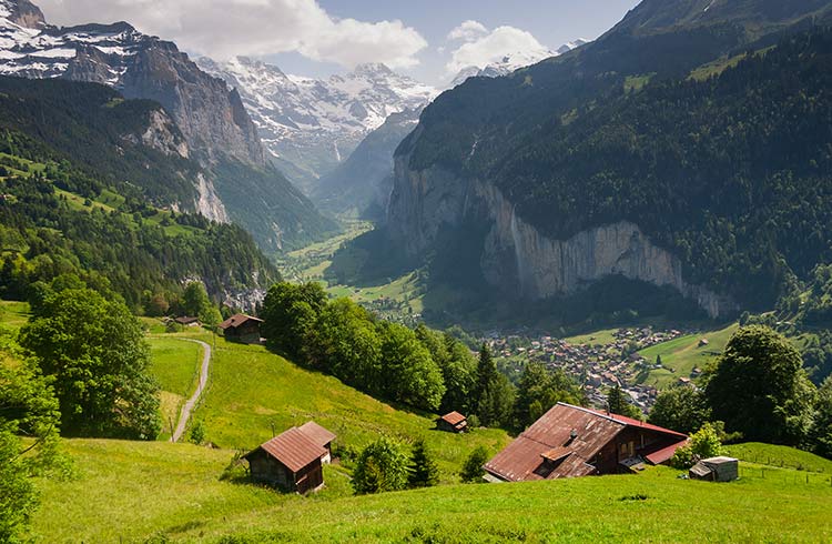
Hiking the Abula Alps near St. Moritz
For about two and a half years, I worked as a journalist for a Swiss news agency in Bern, but still did freelance travel writing on the side. One summer, I got a request to head out to Sils Maria, a small town sandwiched in the Engadin Valley in far eastern Switzerland to check out a hulking, century-old hotel called the Waldhaus. It sits above the valley floor like a fortress and remains suitably opulent, but for my family and me, the real riches came with all the hiking nearby.
More than 360mi (580km) of trails wend around this valley, which is so picture-perfect it almost looks fake. It’s U-shape appears too U, the sky and the grass too saturated with color. Lakes dot the bottomlands like pearls in a necklace, while the Albula Alps scratch 13,200ft (4,023m) into the troposphere. To frolic among it all, there’s little need to sweat. Cable cars, chair lifts, and trains whisk you high into the alpine, where your legs can wander more easily through the best views.
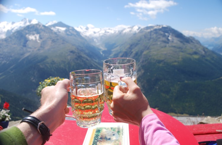
Our favorite hike was no secret, a 5mi (8km) one-way stroll high over the Val Bernina, a valley that crashes into the Engadin Valley from the south. Artist Giovanni Segantini would come up here to paint his 19th-century pastoral masterpieces. To get there, we took a funicular up to a highpoint called Muottas Muragl where there’s a restaurant serving schnapps and soups at about 8,000ft (2,438m). We didn’t stay, but instead, picked our way south along a rocky trail that hugged the contours of the open hillside to reach another hut, the Segantini. We took seats on the warm patio and drank cold beers while staring straight up the Roseg Valley across the way, which looks even faker, frankly. From there it’s only a few more clicks over to Alp Languard, where a cable car spares the knees from the long descent back to earth.
In truth, you can’t go wrong picking almost any hike in Switzerland, and websites such as schweizmobil.ch and map.wanderland.ch detail hundreds of routes in the country. Hikes above Wengen and along the north face of the Eiger (both in south-central Switzerland) will leave you gasping in awe. I’ve also wandered between small tasting rooms in the terraced vineyards of the Lavaux, alongside Lake Geneva. For the hard-core, there’s a new 140mi (225km) hut-to-hut route called the Via Valais that’s a favorite among trail runners, but no reason a hiker couldn’t tackle the shorter sections, too.
I’d go back to that Segantini Hut in a flash, though. This time I might order some cheese and a heavy sausage, and maybe another beer, too, especially if taken on that sun-drenched deck. There’s a great meadow for snoozing it off, just around the bend.
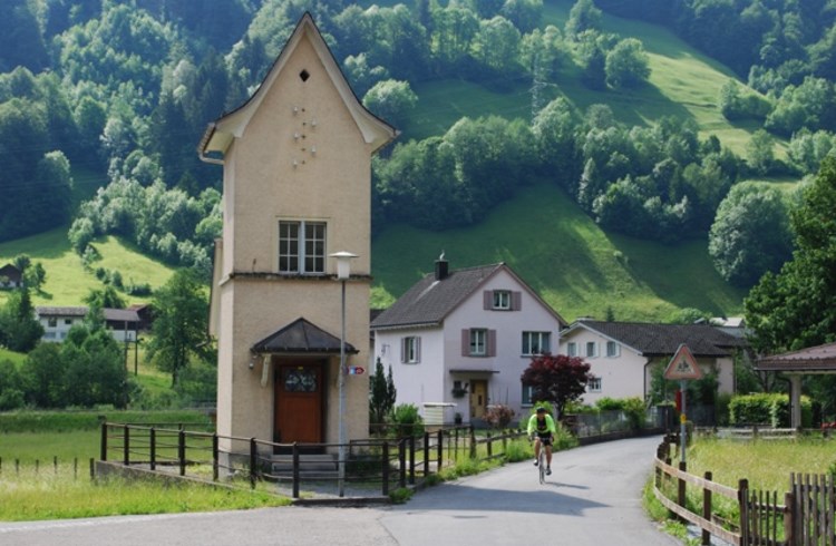
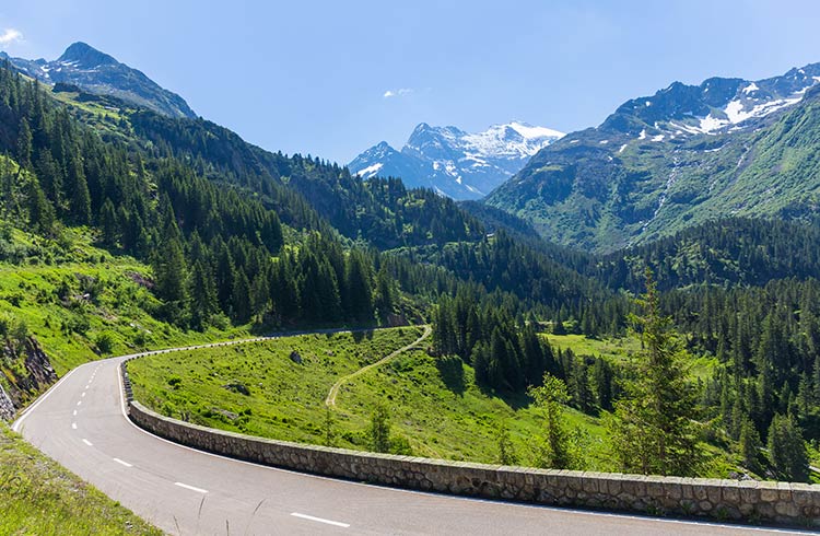
Biking the Alpine Panorama Route
The Swiss take alternative transportation super seriously, and it reflects not just in the quality of their trains, but also in their bike paths, which often have their own traffic lights. You can rent bikes from train stations by the hour, including electric bikes. On weekends, I’d head out on my own bike for long rides around the Mittelland before loading the bike up onto the train for the easy way home. Then, one day, I discovered National Route. No. 4.
Also dubbed the Alpine Panorama Route, National Route No. 4 is one of nine official bike touring routes that crisscrosses Switzerland from border to border, while dozens of other regional routes flesh out a network that includes more than a whopping 5,000mi (8,045km) of dedicated paths.
Even so, No. 4 stands out. It runs for almost 300mi (475km) from the village of St. Margrethen on Lake Constance in the northeast to the town of Aigle, near Lake Geneva, in the southwest, taking in some of the most dramatic scenery in Switzerland. You roll along country byways, through lonely larch forests and across pastures on paths much too narrow for cars, with immense views of high scrappy peaks at almost every turn. You pay for those views, of course, with 30,500-vertical-feet (9,300m) of climbing across the entire route, which you could do in about a week. The great thing is that if you get too tired, you can simply toss your bike into a public bus or train and zip ahead to the next segment.
Of course, you’re never too far from a village with a pastry and a warm bed if you stick it out. The highlight for me was the 90mi (145km) stretch between Appenzell and Flüelen, which included a grind up the airy 6,390ft (1,948m) Klausenpass. I pedaled breathlessly under towering rock walls and up into a hanging valley lined with snow, stopping for a much-needed rest at the top. The ride down was one of the most exhilarating roller coasters ever, with sharp turns hugging sheer cliffs that encourage you to use your brakes.
Friends tell me about mountain biking in the Jura along the French border, like on the 22mi (35km) Flowiger Trail or the entire Jura Traverse, a challenging 260mi (419km) route that follows the crest of the range. The Heart Route runs for 400mi (644km) through the middle of the country and is perfect for electric bikes, with places to change and charge batteries along the way. But No. 4 kept calling me back.
I split the ride over the Klausenpass into two days, and spent the night in Linthal, not far from where zealots executed Anna Göldi, “Europe’s last witch,” in 1782. Back down in Flüelen, I did what I always did at the end of a ride – eat 16 cheese pies and plot my next ride.
Related articles
Simple and flexible travel insurance
You can buy at home or while traveling, and claim online from anywhere in the world. With 150+ adventure activities covered and 24/7 emergency assistance.
Get a quote
No Comments