Australia is blessed with numerous multi-day hikes that do wonders for your mood as well as your fitness. Offering a variety of terrain and levels of difficulty, these six walks feature some of Australia’s most iconic landscapes – cinematic coastline, rugged gorges, and ranges rich in wildlife.
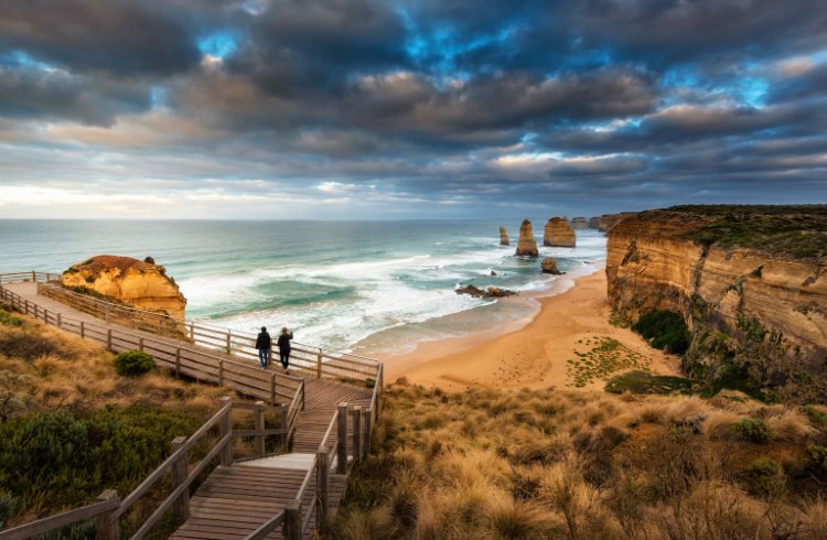 Photo © Getty Images / NitiChuysakulPhotography
- The Great Ocean Walk, Victoria
- Three Capes Track, Tasmania
- The Heysen Trail, South Australia
- Cape to Cape Track, Western Australia
- The Larapinta Trail, Northern Territory
- K’Gari/Fraser Island Great Walk, Queensland
The Great Ocean Walk, Victoria
The Great Ocean Road is rightly celebrated as one of the world’s most beautiful coastal drives. But seeing southwest Victoria’s dramatic coastline whizz by from a car window doesn’t do it justice. For the full surround-sound, all-senses-activated experience, you really need to leg it.
The Great Ocean Walk traces a 68mi (110km) trail along this sensational shoreline, from the beach resort of Apollo Bay to the ocean-stranded limestone stacks of the 12 Apostles.
Its attractions are too numerous to list but highlights include a kaleidoscope of oceanic blues, the fantastical forms of crumbling limestone coastline and the remnant patches of Gondwanaland rainforest. Not to mention the abundant wildlife, especially koalas. Always look up.
You’ll want to allow eight days to go the full distance. Various operators offer guided hikes along parts of the track but it’s relatively easy to DIY with a little planning, such as booking campsites in advance (for less than AUD $20 a night). Or you can sample small sections on day walks. The Cape Otway to Aire River stretch meanders through national parkland via cliffs, dunes and, if you fancy, a short detour to Rainbow Falls.
My favorite short walk is the last leg from tiny Princetown, in the pretty Gellibrand River Valley, to the 12 Apostles. It’s about four hours’ return and worth every step. The famous landmark appears even more impressive from the beach, where you’re dwarfed by its enigmatic stone forms. Time your return for late afternoon when Princetown’s emerald hills come alive with kangaroos.
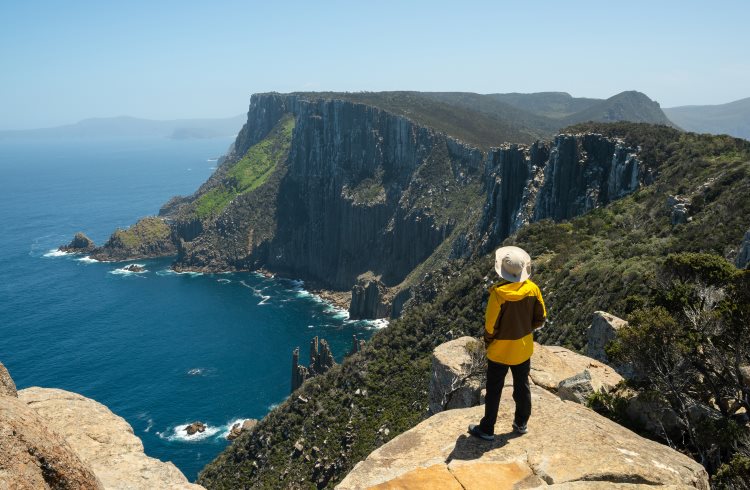
Three Capes Track, Tasmania
Anyone familiar with Game of Thrones will recognize this bleak, beautiful, and barren setting. The 984ft (300m) sea cliffs, the highest in the Southern Hemisphere, tower above an inhospitable ocean and recall Pyke, the forbidding capital of the Iron Islands.
The comparison is apt because this is arguably Australia’s most cinematic great walk, as well as one of its newest, opening in 2015. The 30mi (48km) trail traverses heathlands, rainforest, and those lofty cliffs, battered by Roaring 40s winds and often accompanied by sightings of whales, dolphins, and the odd solitary albatross.
It’s possible to do the walk privately, staying in designer lodges, but most go it alone. Tasmania’s Parks & Wildlife Service has created a self-guided walk (cost AUD $495 pp) with overnight accommodation in shared cabins and cooking facilities for up to 36 walkers. Departures are thoughtfully staggered to ensure the remote trail never feels crowded.
All you need do is pack sufficient food and water and appropriate gear for a quicksilver climate that can shift from blazing sunshine to driving rain in the blink of an eye.
At times, such as perched atop the jagged dolerite columns of Cape Pillar, it feels as if you’re standing at the edge of oblivion. There really is nothing between you and Antarctica, and it’s this exhilaration of isolation that defines the Three Capes Track. Any minor inconveniences caused by the weather are soon forgotten; the sense of achievement and awe stays with you always,
The Heysen Trail, South Australia
The 746mi (1,200km) Heysen Trail, named for the artist Hans Heysen who immortalized its landscapes on canvas, is an epic hike along the spine of South Australia that requires extensive planning but delivers exceptional rewards.
The full trek would take up to 60 days to cover from coastal Cape Jervis to its northern trailhead at Parachilna Gorge. For me, the trail’s high point is the Flinders Ranges, a magical place of beehive-shaped hills and ancient ranges sacred to the Adnyamathanha people. It’s a land, as Heysen famously said, of “skies hard blue and colors dry and crumbly”.
From Wilpena Pound, a natural amphitheatre wrought spectacularly in stone, a four-day slice of the trail heads south through the Ikara-Flinders Ranges National Park for more than 37mi (60kms) to reach the town of Hawker.
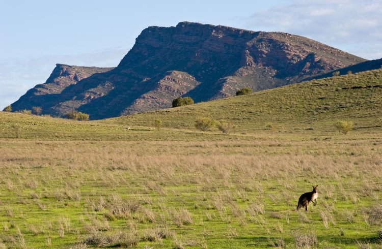
The varied route, set to a soundtrack of cicadas and birdsong, passes lonely sheep stations, whimsical rock formations and wildlands of bullock bush, native pine, and gnarly river red gums. Kangaroos and emus are constant companions; keep eyes out too for echidnas, bearded dragons and, if you’re lucky, rare yellow-footed rock wallabies.
Simple campsites bookend each day. You’ll need to carry all gear with you – swag, food, tent – which, coupled with its remoteness, makes this walk more challenging than most.
Much of the trail closes for the summer bushfire season. Plan to go mid-autumn or mid-spring when daytime temperatures are mild/warm but nights can be chilly. Ideally, you’ll have your own wheels because the bus from Adelaide only goes as far as Hawker, though it’s possible to arrange transfers from there. See the trail website for all the critical info including detailed maps for download to GPS or Google maps.
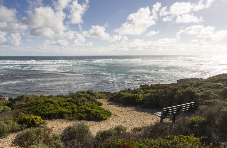
Cape to Cape Track, Western Australia
This 84mi (135km) coastal path between Cape Naturaliste and Cape Leeuwin is like walking at the end of the Earth, with bonus whale sightings in winter and untamed beauty any time of the year. Picture granite capes and headlands, limestone cliffs and labyrinthine caves, and languid sweeps of deserted sandy beaches.
The track offers Indian Ocean views from every angle – atop headlands, from sun-baked beaches or glimpsed through forests and scrubland – but such views come at a cost. Hikers must bring plenty of water (at least two quarts/liters per person on day walks; double for overnight); proper sun protection (hat, glasses, sunscreen etc), first-aid kit, as well as camping gear and food.
There are four campsites well-spaced along the route. Private operators offer more refined accommodation and, often, shuttle services to and from the track for guests.
The full slog can take a week or more to complete, depending on your fitness level. Parts of it are grade four, for experienced hikers, but for less hardy types it’s possible to drive to access points and tackle simpler sections such as the 11mi (18km) segment from Yallingup to Moses Rock via irresistible swimming beaches (mind the surfers at Injidup).
The track winds from the northern tip of the Margaret River wine region to its southern tip, so creature comforts are never far away.
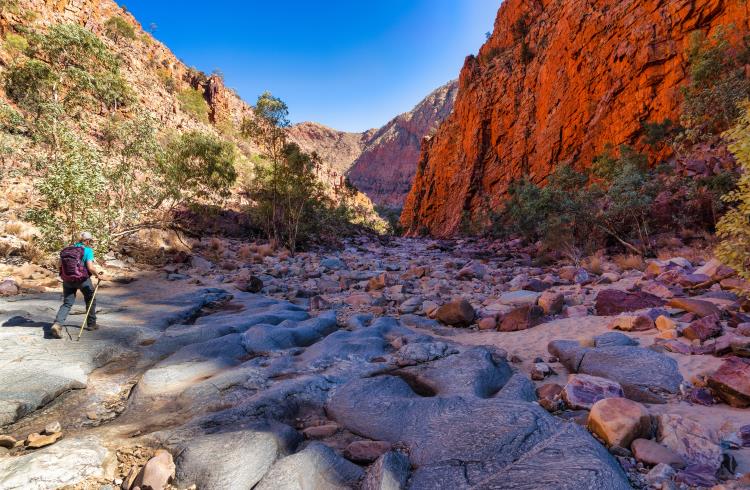
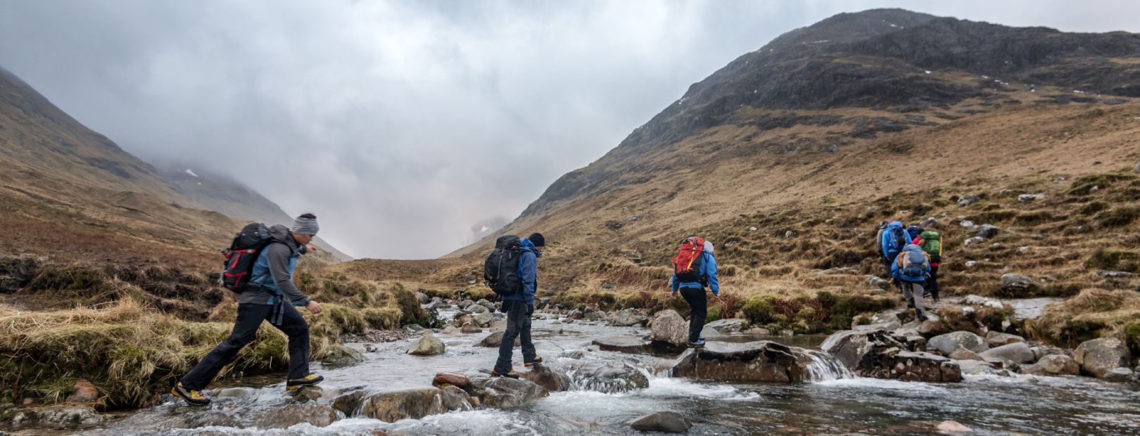
The Larapinta Trail, Northern Territory
The start of the Larapinta Trail, at the old Alice Springs Telegraph Station, is a hushed and ancient place that sets the tone for this 14-day, 139mi (223km) passage through Central Australia. The route follows the West MacDonnell Ranges, a venerable mountain chain once as high as the Himalayas but eroded over time to human-scale peaks.
Much of the journey traverses low mountains and gorges via outback rivers and creeks, with an optional final summit of the 4,524ft (1,379m) Mount Sonder, the ideal setting for sunrise.
Larapinta is split into 12 sections that range in length from a 5.5mi (9km) stroll through the rippled quartzite cliffs of Ormiston Gorge to a 19mi (31km) trek through scenic but remote Hugh Gorge, an oasis walled in red rock.
It’s best to walk between April and August (during Australia’s autumn and winter months) when days are sunny and mild. Trailheads at the start of each section provide some shelter and essential facilities such as water and toilets. Rather than try to go it alone (utter madness), it’s wise to engage Larapinta Trail trek support who can cache food for you along the track, hire gear, and arrange vehicle transfers.
Camping fees aside, the walk was previously free but, at the time of writing, the NT Parks and Wildlife Commission plans to bring in walking fees from March 2022.
Too posh to backpack? World Expeditions pioneered guided walks here in 1995 and offer abridged six-day outings with purpose-built camps and everything taken care of.
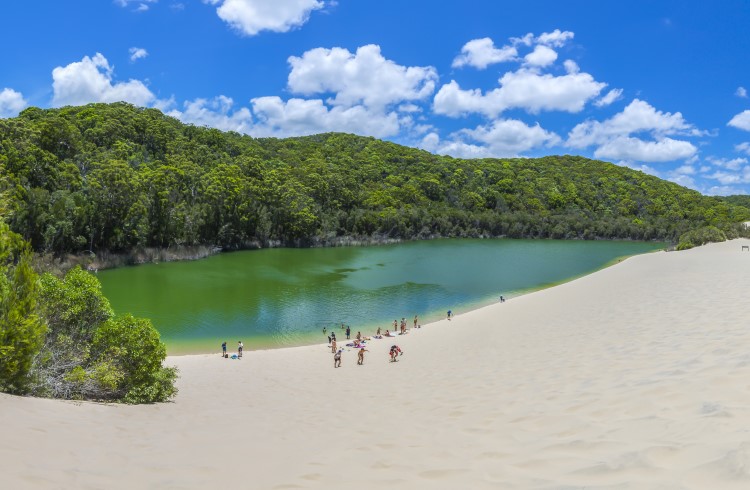
K’Gari/Fraser Island Great Walk, Queensland
Fraser Island was officially renamed K’Gari in 2017 and the new name, which means paradise in the language of the island’s Butchulla custodians, is the perfect fit. This 75mi-long (120km-long) haven in southern Queensland is the world’s largest sand island, but its attractions go far beyond beautiful beaches (all 155mi/250km of them).
K’Gari’s unique ecosystem includes giant dunes that rise to 787ft (240m), abundant lakes, subtropical rainforests, and stunning wildflower displays in spring and summer.
The Great Walk is an eight-day, grade-four amble along 56mi (90kms) of mostly sandy tracks that follow original Butchulla pathways, old logging roads, and tramlines. There are numerous sites of significance to the Butchulla people, including middens and scar trees.
Most sections meander between lakes and bays so days can start and finish with a dip in crystal clear waters, one of the great delights of this hike. But K’Gari is remote and facilities are sparse so this is far from a frolic.
Walkers need to BYO everything, including map and compass (mobile phone coverage is limited), all food and camping equipment. Simple National Parks-operated campsites cost less than AUD $7 per person a night. Importantly, all waste – including toilet waste – needs to be carried out with you. A small price to pay to keep this paradise pristine.
Related articles
Simple and flexible travel insurance
You can buy at home or while traveling, and claim online from anywhere in the world. With 150+ adventure activities covered and 24/7 emergency assistance.
Get a quote
No Comments