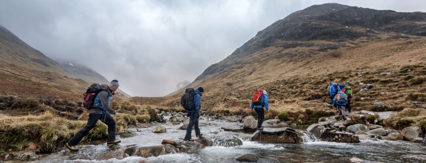
With its broad diversity of terrain and climate, the United States offers fantastic hiking every month of the year. Our nomads share their favorites – from easy day trips to multi-day treks – that let you enjoy the best of the seasons and the regions while avoiding the crowds.
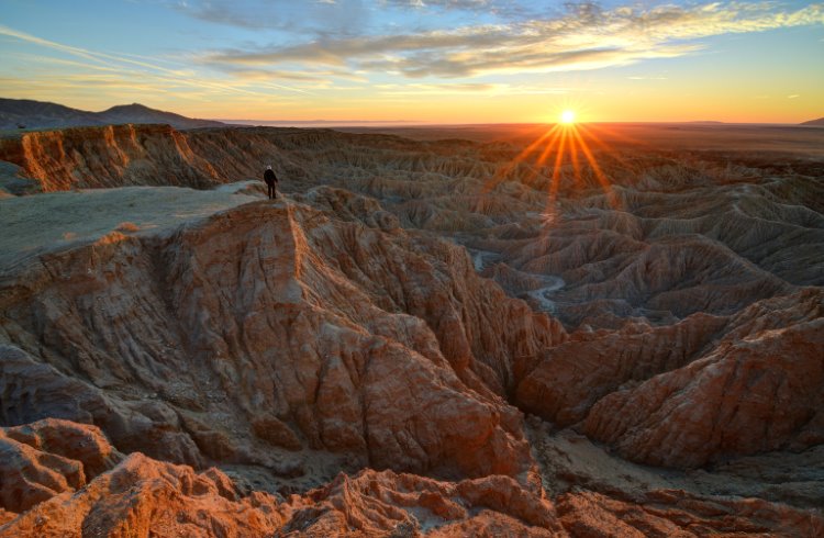 Photo © Getty Images / sierralara
- January: Torreya State Park, Florida
- February: Beartooth Mountains, Montana
- March: Oregon Coast Trail
- April: The Historic C&O Canal Towpath from Harper’s Ferry to Washington, DC
- May: Green River Lakes Trails, Wyoming
- June: The Ozark Highlands Trail, Arkansas
- July: Mountains-to-Sea Trail, North Carolina
- August: Desolation Wilderness, Northern California
- September: The Cliff Walk, Newport, Rhode Island
- October: Meyers Beach Sea Cave Trail, Wisconsin
- November: Anza-Borrego Desert State Park, Southern California
- December: Acadia National Park, Maine
January: Torreya State Park, Florida
Being a keen birdwatcher has only deepened my appreciation for trees, despite their habit of obscuring the objects of my attentions. In fact, I’ve become something of a tree-spotter. It was to satisfy this interest that I first visited Torreya State Park, on Florida’s Panhandle, between Tallahassee and Pensacola. There, growing only on the bluffs some 150ft (46m) above the Apalachicola River, can be found the torreya, aka the stinking cedar or gopher tree, the rarest evergreen in North America. It has been critically endangered since 1998, due to fungal blight.
Unapologetically rugged – and occasionally challenging, because of the aftermath of 2018’s Hurricane Michael, the 12mi (19km) Torreya Challenge trail takes in most of the park’s highlights, such as Gregory House, an antebellum mansion, which can be toured; Confederate cannon emplacements; and glorious stands of white oak, water hickory, Florida maple and fan-leaved palmetto. The neighboring Apalachicola Bluffs and Ravines Preserve, a longleaf pine landscape restored by The Nature Conservancy, where 47 zoo-raised non-venomous eastern indigo snakes were recently introduced, makes for exceptional hiking, too.
January is the best time of year to visit; the mosquitoes haven’t stirred yet, but it’s warm enough for light clothing, and you might see the golden-crowned kinglet, which spends the winter there.
The park is open every day from 8am to sunset and entry costs US $3 per vehicle and US $2 for pedestrians and cyclists. A yurt, cabin, and 30 shaded campsites with restrooms, showers, and electric and water hookups accommodate overnight visitors. – Joe Furey
February: Beartooth Mountains, Montana
Snowshoes are a bit of a misnomer. Since they work by distributing weight over a larger surface area, they’re actually flotation devices. The Beartooths, however, are aptly named. These snow-capped peaks, straddling the Montana/Wyoming border, look like the canines you’d expect a grizzly to flash right before he eats you.
Fortunately, it’s February. Bears are hibernating. Avalanches are a concern at higher elevations – the Beartooths boast Montana’s highest point (elevation 12,779ft/3,895m) – but the trail I’m on, Wild Bill Lake Loop, is lower. Well-groomed and well-marked, it’s as flat as the Beartooths are jagged.
As a Big Sky Country native, I know the Beartooths’ premiere hike is The Beaten Path – a 26mi (42km) summit-to-summit trail that takes 2 to 4 days. I only have 2 to 4 hours. Luckily, there are a dozen easy and moderate hikes, including Wild Bill, within 20 minutes of Red Lodge (pop. 2,012), the gateway to this relatively underrated Montana mountain range.
In October, snow begins to filter through the lodgepole pines to blanket the forest floor. In December, The Beartooth Recreational Trails Association starts grooming its winter-use trails on a weekly basis, and Red Lodge stores rent out Nordic skis and snowshoes.
I opt for the latter so my lumbering 150-pound Leonberger dog can keep up. Because the trails aren’t crowded – even on weekends – dogs are allowed off leash. I dread the day the Beartooths become so popular it’s hard to find parking at the trailheads. That said, I’m not going to stop bragging about my backyard. Mountains this special only form once in a millennium. – Katie Jackson
March: Oregon Coast Trail
A few years ago, a travel editor sent me to the southern Oregon Coast to ride a fat bike along the broad, sandy beaches that make up a good portion of the Oregon Coast Trail. It’s a 362mi (583km) route along the Pacific that links state parks, campgrounds and quaint towns anchored by inns, seafood shacks, and breweries. Even as a longtime Oregon resident I thought the route was awesome, but it was the whale sightings that have kept me coming back.
The OCT isn’t as well-known as a lot of the other long-distance trails in the United States, but it is worthy for its simplicity. The entire Oregon coast is public land, and the route stretches from the mouth of the Columbia River near Astoria south to the California state line. It’s hard to get lost with a giant ocean to orientate you. Along the way you’ll find beaches, single-track trails, and a few stretches of road, none of which is heart-crushingly difficult.
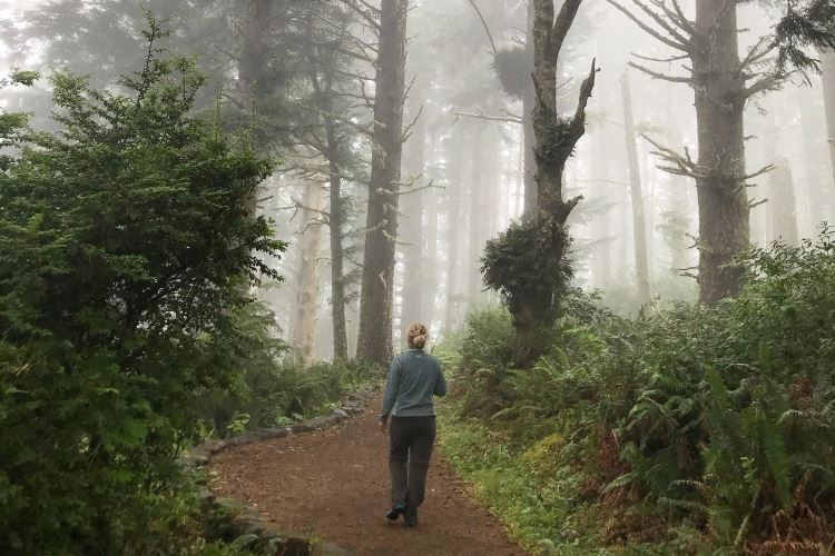
The rewards are magnificent. Temperate rainforests give way to mountain vistas overlooking mighty sea stacks. Tide pools teem with starfish and green sea anemones. And, come March, thousands of gray whales start passing by on their migration north to the plankton-rich waters of British Columbia and Alaska. On some days, it’s not unusual to count 50 of them.
The areas around Depoe Bay rank as prime whale watching regions, but my favorite has always been the 4.5 mile (7km) one-way stretch between Sunset Bay State Park and Cape Arago State Park near Coos Bay in the south. Rocky, dramatic, and less visited, the trail winds along sandstone cliffs, twisted like taffy, and past Shore Acres State Park with its lovely botanical gardens. Bring binoculars to look for the tell-tale spout of a whale coming up for air. When night falls, build a campfire on the beach and roast mussels harvested off the rocks. All you need is a permit. – Tim Neville
April: The Historic C&O Canal Towpath from Harper’s Ferry to Washington, DC
Just across the Potomac River from historic Harper’s Ferry, West Virginia, pick up the C&O Canal Towpath for a mostly flat, 60mi (97km) hike or bike into Washington, DC. I love this stretch of the trail for the scenery, especially in the spring, when native rhododendrons, wild azalea, and dogwood bloom, pawpaw give off their curious fruit (taste it if you like), and bluebells, bloodroot, lilies, and trillium pop up from the forest floor. On more isolated spots along the trail, I’ve spotted white-tailed deer, wild turkey, and foxes, plus abundant bird life.
The entire 184mi (297km) towpath forms the Chesapeake & Ohio Canal National Historic Park, which runs from Cumberland, Maryland, near the Pennsylvania border, all the way to Georgetown in DC. Canal boats were once pulled by mules along the towpath, hauling passengers, coal, food, and other supplies. For nearly 100 years of the 19th and 20th centuries, the canal was a key supply route to Western Maryland and beyond. Wooden locks raised and lowered boats to allow for elevation change – a few of them still function and many others are in a preserved state.
Today, the towpath is a wide, shady trail for walkers, backpackers, and bikers content to traverse a small section or make the entire journey end-to-end, with stops along the way at campsites or country inns. The towpath is shaded almost the entire way, but still offers dramatic views of the roaring Potomac, imposing rock formations, and fascinating history lessons – all at a pace that won’t leave you winded. – Elizabeth Heath
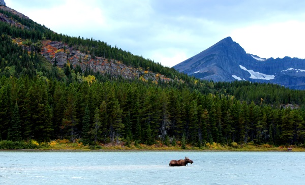
May: Green River Lakes Trails, Wyoming
I dedicated my time in Wyoming to lesser-known hiking destinations. Sure, Yellowstone and Grand Teton National Park are both spectacular, but they’re also spectacularly crowded. While national parks get all the attention, national forests, such as Bridger-Teton, are massively underappreciated – huge swaths of public land just begging to be explored.
The Bridger Wilderness area inside Bridger-Teton National Forest is 2.5 hours south of Jackson, Wyoming and 1.5 hours north of Pinedale (where I was based) – far enough off the main drag that it’s not overly crowded but close enough to civilization that daytrip hikes are possible. Overnight camping is also an option – and the only option for multi-day hikes.
The Green River Lakes trail network is especially beautiful, with the Green River Loop (a 7mi/11km loop around a lake) the most popular. For multi-day hikers, the Highline Trail is a 35mi (56km) out-and-back trek with campsites scattered along the route. Instead of taking the Highline Trail to the Lakeside Trail to complete the lake loop, I opted to continue on the Highline side since the Lakeside Trail was full of downed trees. Just 3mi (5km) from the Highline trailhead I was rewarded with views of snowcapped mountains reflecting off the emerald and turquoise lakes. If you want to get that epic view but complete the loop, just double back a bit to connect to the Lakeside Trail.
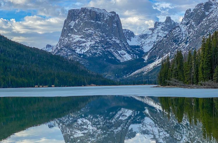
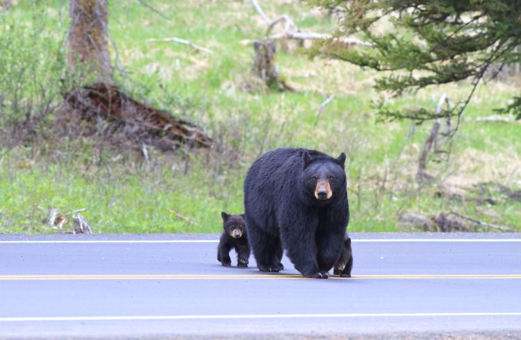
By early May, most snow is melted along the trails, there are no mosquitos yet, and pre-summer vacation season means few crowds. Elevation gains are fairly minimal and not too strenuous. Though hiking poles aren’t necessary, the terrain is easier in proper hiking boots, and bear spray is absolutely essential. This part of Wyoming is prime bear country (both black and grizzly), so be sure to have bear spray handy, wear bear bells, bang sticks, and/or sing while hiking so bears hear you coming.
As I usually hike alone and am terrified of bears, I actually mistook the rev of a distant boat motor for the pounding footsteps of a charging grizzly. For a moment, time stood still while I envisioned a mama grizzly charging me from the forest. My heart stopped, then raced, then I laughed at my mistake. Ten minutes later, I fell for the same motorboat trick again. – Cassandra Brooklyn
June: The Ozark Highlands Trail, Arkansas
Now fixed in the popular imagination by the eponymous TV series, the Ozarks are a heavily forested group of highlands extending southwestward from St. Louis, Missouri to the Arkansas River and take in four states. The Midwest’s answer to the Appalachians, the Ozarks aren’t a mountain range so much as a heavily weathered plateau, one of the oldest on Earth.
The Ozark Highlands Trail is a work in progress. So far, 270mi (435km) of a projected 320 have been cleared, and I’ve tackled 100mi (161km) of it, on and around the Boston Mountains of Arkansas, averaging about 15mi (24km) a day, from the Fort Douglas trailhead to Lake Fort Smith State Park. This is physically demanding backcountry hiking, involving, in summer, a fair amount of bushwhacking, so it’s best to pack light (it’s easy to pitch a mesh tent and a light tarp beneath the dense tree cover that’s a fixture of much of the trail). Fresh water is easy to find, but clean fresh water isn’t, so have a portable water purifier on hand, and a bear canister to contain your vittles, as black bears and raccoons are never far away.
The Trail crosses more than 60 named creeks, streams, and rivers, traverses the Hurricane Creek Wilderness Area and scales White Rock Mountain, and yet it’s lightly trafficked. I was rarely accompanied for long on my trek, so its steep inclines, sudden drops, sandstone cliffs, jungly intensity, and views of what could have passed for heaven felt as though they’d been laid out just for me. I can’t think of another slice of genuine wilderness with its sense of scale and isolation – and populations of elk, mountain lion, and bald eagle – so close to civilization (Fayetteville, Arkansas, is just 40 minutes’ drive from Lake Fort Smith). – Joe Furey
July: Mountains-to-Sea Trail, North Carolina
Strictly speaking, this isn’t the 1,175mi(1,891km) MST – as it’s commonly acronymed – but a 45mi (72km) section of it, ideal for a very long weekend. A friend sold me on this hike, from the town of Asheville to the Black Mountain Campground, as a practice run for an assault on the Southern Sixers, the 53 peaks that stand taller than 6,000ft (1,828m) among the Southern Appalachian Mountains of North Carolina and Tennessee. Other than Mount Washington in New Hampshire, these fairly tightly clustered summits are the only ones that make the cut east of the Mississippi.
Even in July, the walking is cool, thanks to the elevation not dropping below 5,000ft (1,524m) for almost half its length, though a wide-brimmed hat is essential if sunstroke isn’t your bag.
The trail tops out at 6,359ft (1,949m) at Blackstop Knob, but Mount Mitchell – at 6,684ft (2,037m), the highest of the Sixers, and beloved of the Cherokee, who called it Attakulla – is temptingly close, and worth the detour if you have the legs for a much steeper climb.
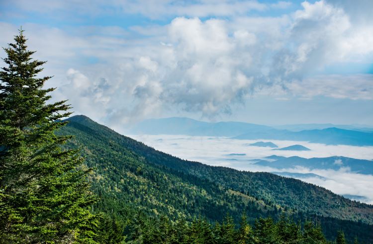
A nine-site tent campground in the free-to-enter Mount Mitchell State Park is open in warmer months, and a concession area and full-service restaurant caters to visitors from May to October.
Many of the trailheads are a short distance from the Blue Ridge Parkway, a manmade wonder, so the journey can be broken up without fuss if you want to use Asheville, with its charming downtown, arboretum, galleries, Pinball Museum and proximity to the historic Biltmore Estate, as base camp. – Joe Furey
August: Desolation Wilderness, Northern California
Above Northern California’s Lake Tahoe is a wonderworld of granite domes, alpine lakes, evergreen forests and bluebird skies that seems to stretch forever. This is Desolation Wilderness, one of the Sierra Nevada’s last strongholds for peace and isolation.
My favorite hike through this 100mi2 (260km2) wilderness area begins at Echo Lake and ends 1,800ft (549m) up at Lake Aloha. You can do this 12mi (19km) out-and-back trip in a day, but I like extending it with a few nights camping along the shores of the numerous lakes found north of here, making a one-way trip from Echo Lake to the Eagle Falls trailhead on Lake Tahoe’s Emerald Bay. It’s 16+ mi (26+ km), connecting numerous trails, so a map and compass are essential.
It’s best to start early to get the best light and miss the day-trippers. This is pure California magic, rewarded by vast views of the Sierra Nevada mountain range, meadows, and granite-shored lakes. There are plenty of chances to spot wildlife, such as mule deer, black bear, badgers, and bobcats, and fun little guys including fishers, pine marten, marmots, and pika. Keep an eye out for jays, chickadee, mountain bluebird and maybe even a golden eagle.
Lake Aloha has probably the best lake swimming I’ve ever done – anywhere. The crystal-clear waters are ice cold, and a wonderful treat after a long slog. After a dip and a serious “lizarding” sunbathing session, I set up camp, take an afternoon hike (without my backpack), or just chill lakeside with my thoughts. If you want to stay for longer, you can camp at any of the lakes enroute to Eagle Falls.
All overnights in Desolation Wilderness require an easy-to-get permit. This is bear country, so be sure to bring a bear canister to store your food well away from the campsite and never, ever cook in your tent. You’ll also need a good tent, sleeping bag and sleeping pad, bug spray, food, water and a water filtration system, and standard mountain trekking gear. In some areas you might be required to pack out your poop (a specially designed poop pouch comes in handy). – Greg Benchwick
September: The Cliff Walk, Newport, Rhode Island
The Cliff Walk, in the classic New England seaside town of Newport, Rhode Island, is a popular destination during the summer season, when crowds flood in. But my favorite time to hike this trail is in September. By then, the air is cooler and the vacationers have left.
The 3.5mi (5.6km) National Recreation Trail offers incredible views of the rocky Atlantic coastline as well as Newport’s iconic, gilded mansions: the Breakers, the Marble House, and the Elms.
The term “walk” is used lightly, because while there are parts that are paved and easy to navigate – especially at the start of the trail – there are also plenty of areas with uneven terrain. Some parts even have steep inclines of over 70ft (21m) and require extreme caution, so make sure to wear some good hiking shoes.
Aside from the thinned crowds, September is also usually warm enough to enjoy the last bits of summer fun, such as the local beaches, outdoor dining, and playing lawn tennis at the International Tennis Hall of Fame. The Newport Mansions Wine and Food Festival is also held mid-month and allows guests the unique experience of wining and dining like a Vanderbilt in the gilded age.
The trail is open 365 days a year and access is free and open to the public. I’ve done the walk several times and no matter how many times I hike this trail, I never tire of the views. – Gina Zammit
October: Meyers Beach Sea Cave Trail, Wisconsin
When I was growing up in Wisconsin, each summer my family would “go up north” (Wisconsin speak for visiting the northern part of the state). This stunning part of the country isn’t well-known outside the region, but it’s packed with gorgeous and unique hiking trails for all skill levels.
My absolute favorite hike in Northern Wisconsin is the Meyers Beach Sea Cave Trail. Located within the Apostle Islands National Lakeshore, the trail meanders along the southern coast of Gitchigami, the name the Red Cliff band of Lake Superior Chippewa gave the Great Lake. As the tribe’s name implies, the region (and the Meyers Beach trail, in particular) is lined with red cliffs and the trail itself is mostly shaded, well-maintained, and easy to follow. If it’s hot out, the best way to cool off is to jump in the lake after the hike.
The first .75mi (1.2km) of the out-and-back trail follows a wooden plank boardwalk, then changes to a mixture of dirt paths and wooden stairs – nothing too technical. Note that if it’s been raining, the trail can get quite muddy and slippery so be sure to bring proper footwear. The first mile is through a densely wooded area that transitions to a waterfront path overlooking Lake Superior and the area’s famous sea caves. Around the 2mi (3.2km) mark – right where the cliffs are – the trail becomes narrow and overgrown, so most people turn around here, but the trail continues for another 3mi (5km) or so, on to the Lakeshore Trail Campsite. If you don’t mind climbing over fallen trees, the full out-and-back route is about 11mi (18km).
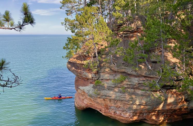
Huge evergreen trees maintain their green hue year-round but each October, maple, birch, and other deciduous trees transition to festive yellow, red, and orange. Come winter, the kayakers who paddled below the cliffs in summer have been replaced with hikers making their way across the frozen-over lake and into the icicle-filled sea caves. – Cassandra Brooklyn
November: Anza-Borrego Desert State Park, Southern California
The California sand was still warm when I collapsed into it, eyes skyward, to watch satellites trace across the stars. The dark was dizzying. A few hours ago I’d been in San Diego wandering the Gaslamp Quarter, but out here I was alone with silhouettes of spindly ocotillo.
I’d never heard of Anza-Borrego Desert State Park until a guide book project I was working on took me there one November – the ideal time to visit. The park sits in the shadow of the more popular Joshua Tree National Park, but this is California’s largest state park, a 600,000-acre expanse of canyons with ancient pictographs, soaring peaks, and ragged badlands.
More than 110mi (177km) of trails wind through the park, including portions of the Pacific Crest Trail, but I’d spent a few days doing smaller day hikes instead. I wandered for 5.5mi (9km) out and back to the 20-foot-high (6m) Maidenhair Falls in Hellhole Canyon, a place that in summer lives up to its name with temperatures that can reach 125ºF (52ºC). I found an oasis of shimmering California fan palms tucked 1.5mi (2.4km) into Borrego Palm Canyon, a haven that has since burned in a small wildfire but that ecologists say will regrow quickly. On my last day, I spent a challenging several hours scrambling up to the cooler climes of 5,600ft (1,706m) Granite Mountain on a trail so lightly used at times it disappeared.
Make no mistake: this is rough, rugged country and even in winter temperatures can still get hot. Be sure to bring a map, don’t expect mobile service, carry lots of water (at least a gallon per person) and, if you’re camping, be sure to carry a headlamp and mark your tent with reflective tape to find it in the dark. Then sit back, turn your gaze to the heavens and watch the show till dawn. – Tim Neville
December: Acadia National Park, Maine
Most people who visit Acadia National Park, one of the country’s most popular parks, with roughly 3.5 million visitors a year, know it as a summer getaway. But the park’s best kept secret is that it’s just as beautiful during the shoulder seasons and, as long as you’re willing to bundle up, you’ll have it all to yourself.
The Gorham Mountain and Ocean Path Loop is a 3.5mi (5.6km) hike that encompasses everything iconic about the park, starting with a moderate climb to the top of 525ft (160m) Gorham Mountain, one of Mount Desert Island’s many mini peaks. From its granite summit spread seemingly limitless views of Frenchman Bay and its conifer-covered islands. My hands glide over snow and icicle-covered rocks on the way down and my boots crunch through iced-over puddles and streams.
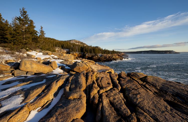
I cross the road to Sand Beach. The Maine ocean is cold year-round, so a walk on its sandy shore is no less enjoyable in the winter and the beachcombing is even better. A short climb brings me to Ocean Path, which hugs the rugged pink granite coastline and parallels Park Loop Road, closed to cars in the winter. Without the noise of the summer’s bumper-to-bumper traffic, the sound of sea birds and crashing surf intensifies and it’s easy to harken back to the park’s less peopled beginnings in the early 1900s when it was a playground to the Rockefellers.
While the island typically gets less snow than inland Maine, be sure to check for weather conditions and dress for cold weather. – Catie Joyce-Bulay
Related articles
Simple and flexible travel insurance
You can buy at home or while traveling, and claim online from anywhere in the world. With 150+ adventure activities covered and 24/7 emergency assistance.
Get a quote
No Comments